The Problem: Why Standard GPS Fails Underground Asset Location
The root cause of most repeat visits is poor location data. Modern utility networks are incredibly dense. Water mains, high-voltage electrical lines, and fiber optic cables often run parallel within inches of each other beneath concrete sidewalks.
When a field worker relies on a standard commercial tablet or a consumer-grade GPS receiver, they are working with an accuracy radius of 2-5 meters. If the digital twin says a critical gas valve is “here,” but the GPS is off by 4 meters, the crew faces a dangerous guessing game. They either initiate a blind, exploratory excavation (risking a strike) or halt the job to call in a specialized surveying team.
Also, urban utility corridors in cities like Dubai and Abu Dhabi frequently contain power, water, gas, telecom, and drainage infrastructure within the same 2-3 metre trench width. When the positional uncertainty of standard GPS (3-5 m) exceeds the physical separation between adjacent utility assets which is often under 1 m, a crew cannot reliably determine which specific asset they are looking at from GPS coordinates alone. This is the single largest driver of mis-identified assets, wrong-asset excavation risk, and repeat visits in dense urban GCC utility networks.
The Solution: A Fully Integrated Smart Inspection Solution
To eliminate the guesswork and reduce repeat visits in utility maintenance, field teams need a unified hardware ecosystem. Precision mapping for utilities requires a rugged device capable of capturing centimeter-accurate data, reading environmental anomalies, and interfacing directly with legacy hardware.
The ultimate smart inspection solution combines three critical hardware capabilities on a single rugged tablet:
RTK GPS (Real-Time Kinematic): Upgrades location accuracy from meters to 1-3 centimeters. This allows crews to walk directly to the exact coordinates of a buried asset without hesitation.
Integrated Thermal Cameras: Allows workers to visualize subsurface temperature variations like a hot water leak or spot overheating electrical transformers instantly, without requiring separate, bulky diagnostic tools.
Native RS232 / Legacy I/O Ports: Many utility networks still rely on legacy flow meters, acoustic leak detectors, or older diagnostic panels. A native RS232 serial port allows the tablet to plug directly into this equipment on-site, bypassing the need for fragile USB dongles that frequently fail in the field.
Real-World Scenario Walkthrough
How does this integrated GIS mapping rugged device workflow look in the field? Let’s look at three critical utility scenarios:
1. Gas Network: Precision Valve Excavation
A gas utility crew is dispatched to investigate a reported odour near a residential connection. With a standard GPS workflow, the crew locates the approximate gas main position from legacy GIS records potentially 3-5 m off, manually probes the area to find the pipe, and if no visible leak indication is found, the visit is recorded as inconclusive requiring a specialist leak detection contractor to be scheduled separately.
With an RTK GPS + thermal-equipped rugged tablet, the crew locates the pipe to centimetre accuracy, uses the thermal camera to identify the characteristic cold signature of an escaping gas leak at the surface (gas expansion causes localised surface cooling), confirms the leak location precisely, and completes excavation planning in the same visit eliminating the separate specialist call-out entirely.
2. Electricity Grid: Substation Diagnostics
An electricity distribution crew is investigating a reported underground cable fault. Standard GPS workflow locates the approximate cable route from GIS records, but cannot confirm fault location without excavating along the suspected route often requiring multiple exploratory digs.
With RTK GPS positioning the exact cable route to centimetre accuracy and a thermal camera detecting the heat signature of fault current concentration at the surface above the fault point, the crew narrows excavation to a single, precisely located dig rather than a series of exploratory trenches along an approximate route. The RS232 serial port additionally allows the crew to pull live load and fault current data directly from nearby RTU equipment on site, confirming the fault signature against SCADA records before excavation begins.
3. Water Pipes: Acoustic Leak Mapping
A water utility inspection crew visits a district metering area to verify pipe condition and pull consumption data from an aging mechanical meter that predates smart metering rollout. Standard workflow requires the crew to manually read and record the meter, then separately note GPS position with consumer-grade accuracy producing a GIS record disconnected from precise pipe routing.
With a rugged tablet’s RS232 serial port connected directly to the legacy meter’s data output, consumption data is captured digitally and tagged with an RTK-accurate GPS position in a single workflow step, immediately syncing to the central GIS and asset management system. The office sees verified, positioned data the same day without a data entry backlog or a second visit to clarify ambiguous handwritten readings.
Also Read: RTK GPS vs Standard GPS for Utility Field Work: Why Centimeter Accuracy Changes Everything
Recommended Devices for Precision Utility Field Mapping
Executing this level of precision mapping for utilities requires enterprise-grade hardware. Consumer devices simply cannot host thermal cameras, native serial ports, and RTK antennas while surviving drops, dust, and rain. For maximum ROI, we recommend equipping your teams with specialized Getac rugged tablet utility inspection hardware:
Getac UX10: A highly versatile 10-inch Windows tablet. It can be custom-configured with hard-handles, native RS232 ports, and paired seamlessly with external RTK receivers. It is the ultimate command center for complex field diagnostics.
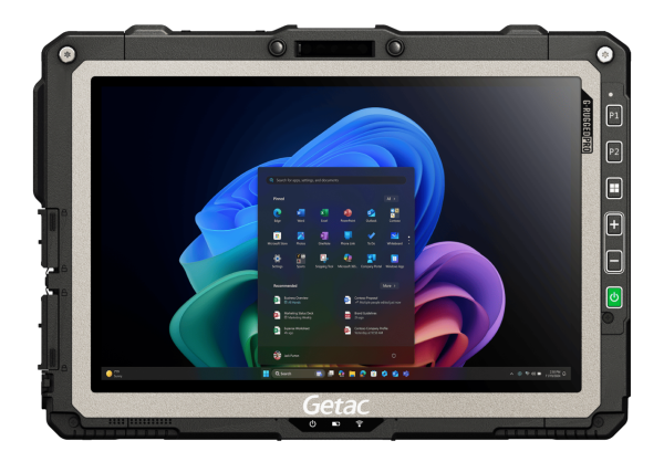
Getac ZX10: The premier Android alternative. Featuring a brilliant LumiBond display and MIL-STD-810H ruggedness, it is perfect for teams relying on modern Android-based GIS mapping apps like Esri ArcGIS Field Maps.

Getac F120: Designed for heavy-duty data processing and intense field environments, offering a larger screen and unparalleled processing power for rendering complex, multi-layered CAD and GIS utility maps directly at the excavation site.
Getac Device Recommendations: Precision Utility Field Mapping

| Device | Best For | Key Differentiator | Form Factor |
| Getac UX10 | GIS-heavy workflows; Esri ArcGIS Field Maps power users; Windows SCADA integration | RTK-ready GNSS, 1000-nit sunlight display, LTE Cat12, full Windows app compatibility | 10.1″ detachable tablet |
| Getac ZX10 | Android-native field apps; barcode/RFID-driven asset inspection workflows | Integrated barcode/RFID scanner, RTK-capable GNSS, lighter form factor for handheld use | 10.1″ Android tablet |
| Getac F110 | Multi-tool field work requiring thermal imaging, RS232 serial I/O, and GIS in one device | Modular expansion bay (thermal camera, barcode, RS232/serial, smart card), MIL-STD-810H | 11.6″ fully rugged tablet |
FAQ: Utility Field Operations Inefficiency
How does RTK GPS reduce repeat visits for utility operators?
RTK GPS provides centimeter-level accuracy of 1-3 cm compared to the 2-5 meter accuracy of standard GPS. This precision allows utility workers to locate buried assets like valves and pipes instantly on their first visit, eliminating the need to call out secondary surveying teams or perform exploratory excavations.
What causes the most utility field operations inefficiency?
The most significant cause of inefficiency is inaccurate or inaccessible field data. When workers cannot accurately locate an underground asset, or lack the correct diagnostic interface to communicate with a local control panel, work orders are delayed, resulting in costly repeat visits and extended asset downtime.
What is RTK GPS used for in utility mapping?
RTK GPS is used to map and locate buried utility assets with high-precision, centimeter-level accuracy (1-3cm). It is critical for capturing exact coordinates during GIS field data collection, establishing accurate digital twins, conducting precision excavations, and preventing accidental utility strikes on dense networks.
Why is a native RS232 port important on a GIS mapping rugged device?
Many water, gas, and electrical grid diagnostic tools like acoustic leak detectors or legacy flow meters still output data via RS232 serial connections. A rugged tablet with a native RS232 port allows workers to plug in directly and reliably in the field, avoiding fragile USB-to-Serial dongles that easily break or lose connection in harsh environments.
What is the best rugged tablet for utility inspection?
The best tablet depends on your software ecosystem, but the Getac UX10 (Windows) and Getac ZX10 (Android) are widely considered industry standards for utility work. They offer sunlight-readable displays, IP66 waterproofing, and can be configured with specialized tools like barcode scanners, thermal cameras, and secure RS232 ports to serve as a complete smart inspection solution.
How can operators reduce repeat visits in utility maintenance?
Operators can reduce repeat visits by equipping field teams with smart inspection solutions that combine centimeter-level RTK GPS, integrated thermal imaging, and native legacy ports like RS232.
What is the difference between standard GPS and RTK GPS?
Standard GPS relies only on uncorrected satellite signals, resulting in a broad 2-5 meter error radius. RTK GPS introduces real-time corrections from a localized base station or cellular NTRIP network, correcting atmospheric and signal errors to reduce horizontal positioning variance to a mere 1-3centimeters.
Sourcing Getac Solutions in the UAE and GCC
Amplicon Middle East is an authorized Getac partner and a leading distributor in the GCC. We provide fully certified hardware, tailored to your specific deployment needs.
Contact us today to discuss your technical requirements, request a quote, or check current inventory at our Dubai facility.